RICHARD WILLIAMSON: Country walk: East Head


I am no expert with the physiography down there, but that is what I thought.
It made the walk for me almost as exhilarating as that which I once made over Morecambe Bay: and that’s saying something. I went down to see what sort of punch-up the sea has had with the famous sand spit because I can remember the storm surge in the 1960s that washed away the whole neck which was then built back by prisoners from Ford Open Prison, using bulldozers.
Advertisement
Hide AdAdvertisement
Hide AdTo make this walk of 2.2 miles (3.5kms) you would have to go just before dead-low water around midday, which brings it five days before the new or the full moon. Park in the West Wittering car park SZ765983 which in winter seems to cost £2.50.
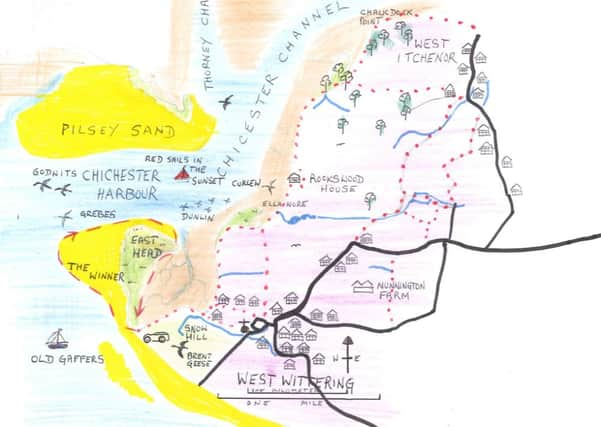
A slot machine is now in operation. My photo taken last week shows where you start the walk by going down to the most northerly breakwater with its upright marker. Then turn right into the harbour, along The Winner shoreline.
Most people take the safe route along the sand dune shoreline, but mine is more exciting.
This is not a public footpath, but the National Trust allows access.
Advertisement
Hide AdAdvertisement
Hide AdWith the tide so low and provided the wind is light and not creating waves, you can now follow the shoreline out northwest towards the centre at Stocker’s Lake.
There are tidal pools you’ll have to wade maybe, and now and then your feet start to sink in slight quicksands, but that just adds to the spice.
To the left is the Hayling Island shore with its boats and yards and buildings. There is the Portsmouth Spinnaker Tower, and the heights of Portsdown Hill with Forts Widley, Purbrook, and Farlington Redoubt on Camp Down.
Lower down, the green hangars of Thorney Army camp are visible behind the trees. Then moving right, Pilsey Island comes into view with its shingle and sand dunes, and its lower necklace of black seaweed wrack along the tideline.
Advertisement
Hide AdAdvertisement
Hide AdBefore you, the deep channel becomes buckled blue in wind and tidal race.
Far ahead on the skyline is what sometimes looks like a small mountain.
It is Bow Hill, with Kingley Vale below. This viewpoint will bring you now and then a few glimpses of this harbour’s rarest treasures: see opposite for what I found there.
The walk just follows the tideline onwards to the spit head, the apogee of sand and shingle where it falls quite suddenly into the sea.
The way back is along the saltmarsh path on the sheltered east side of the spit. To explore all the 90 species of plants that grow there is for another day, in summer.